What's New
- Structures Inspector mobile app enhancements
- Work Manager mobile app enhancements
- Maintenance Manager and Structure Inspector web application updates
New Features and Enhancements
Structures Inspector mobile app
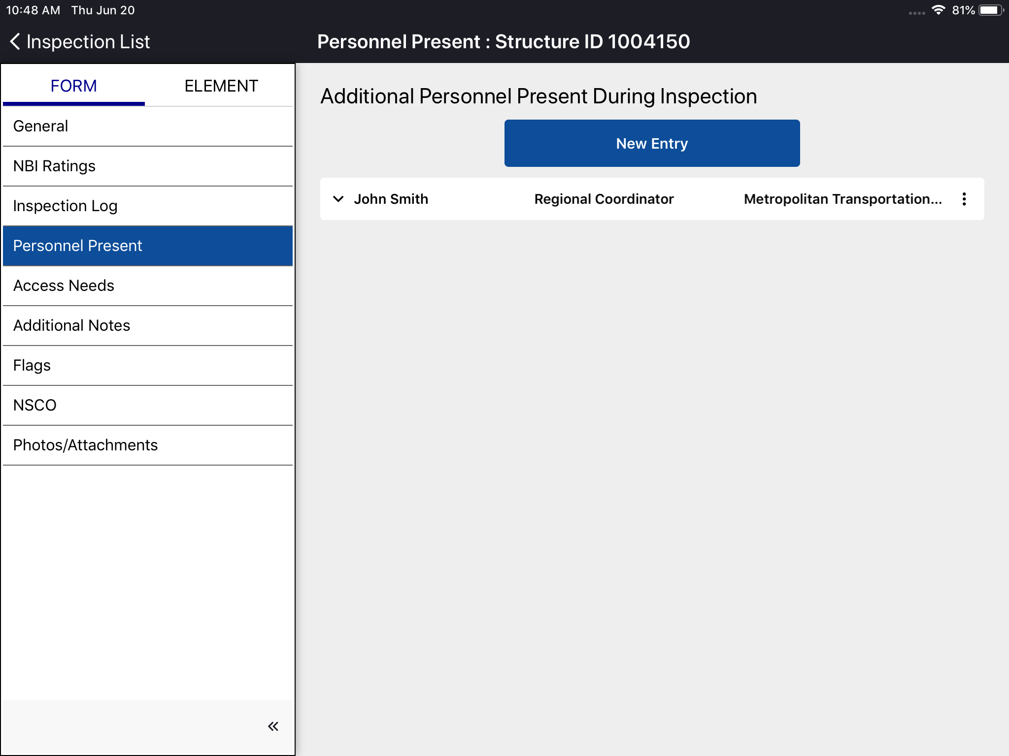
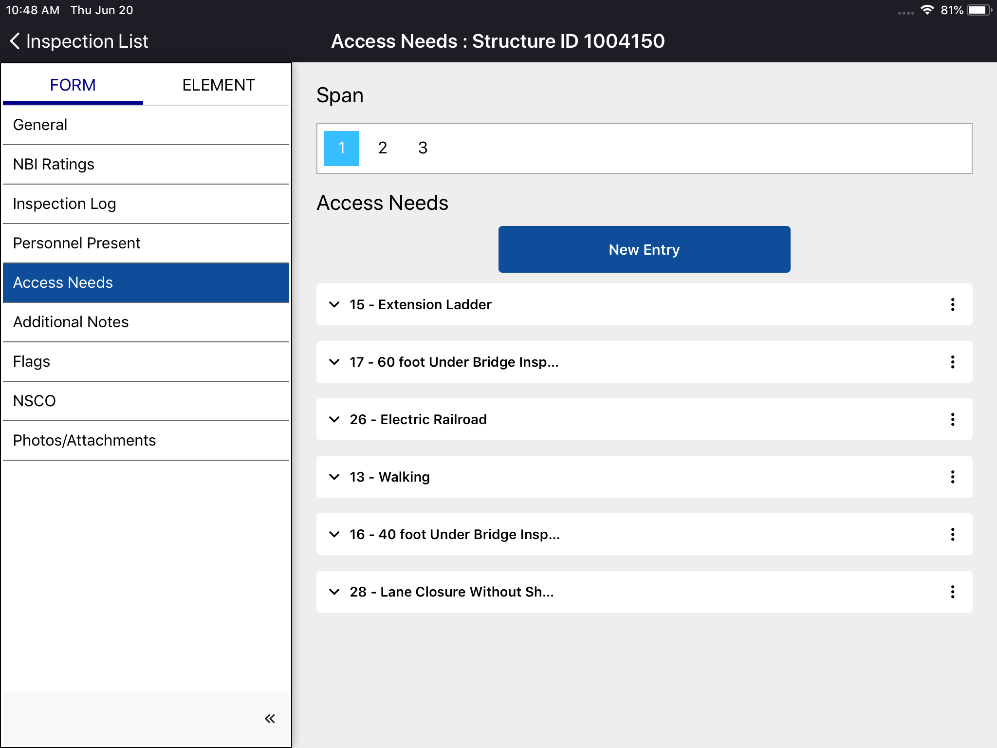
The structures inspector mobile app has been enhanced to allow inspection teams to record notes from the field which include, inspection day log, personnel present for the inspection and information needed to access the structure being inspected. This version also includes additional capabilities to flag creation.
Field notes have been added so users can document the following information:
- Inspection Log: A record of the weather conditions, temperature, arrival and departure times for each day of an inspection
- Personnel Present: A record of who (in addition to the lead inspector) was present over the course of the entire inspection
- Access Needs: A record of access equipment and notes for future inspectors on how to access the structure
- Additional Notes: General notes to the next inspector, any observed improvements and the presence of pedestrian and snow fences
Improvements to flag creation include the ability to select existing flags that the new flag would supersede as well as business rules for validating required fields and auto-population of certain field based on the allowed value.
Work Manager
Work Manager users will now be able to copy Day Cards from one day to the next. There is validation in place to ensure that data already entered into the Day Cards isn't overwritten or duplicated during the copy forward process.
The user can now easily create day cards for multiple days, and can select more than one piece of equipment, more than one worker, more than one material, etc to create multiple day cards for a given work date in a single step.'
| Note |
|---|
| Note: A day card is always a transaction noting the usage of one resource (labor, equipment or material) on a single work date. Need to be careful to convey this. What is changing is the ability to batch create multiple day cards at once. |
There is now a user-friendly interface that validates the data on the day card and provides a green check mark when the data is valid and ready to sync.
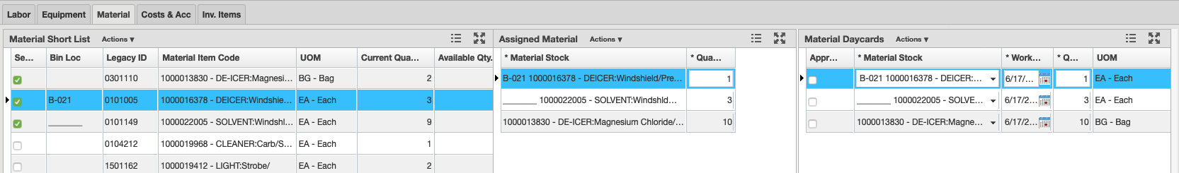
When selecting a Material Item, the app now provides users with the following information:
- The balance on hand (remaining quantity) in the selected material stockbin as well as the unit of measurement for each item of available stock
- Metadata in the search results for date of last sync and available stock on each material
- The current balance on hand for stockbins is returned on sync
- When searching for a new material, the already selected items are still visible in the list
Additionally:
- Asset now supports updated LRS assets by:
- Providing information on whether each asset is an LRS asset
- Providing the geometry type for each asset - Point, Line, or Polygon
- Calculating geometry per rule even when Geometry Type is not set in the Setup Asset Type table
- Geometry Type field on Setup Asset Type Table is now set as non-nullable
- When a System Admin runs the system job to recreate the Asset View, the same job will now cleanup the Change Data Capture table
Maintenance Manager
Related Labor, Equipment, and Material rows in both the Short Lists and Assigned panes of the Work Orders window are now highlighted if the corresponding item on an Labor, Equipment, or Material day card is selected in the Day Cards pane.
Structure Inspector
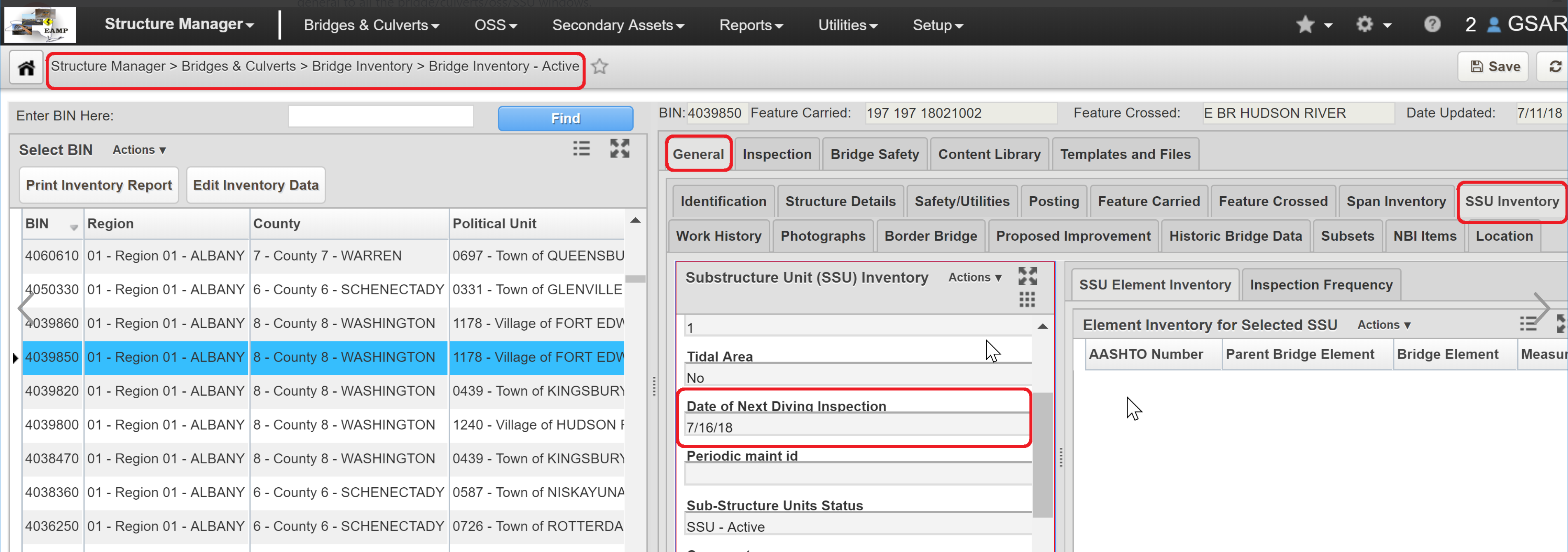
System job has been created that calculates dates and sets them for bridges.
| Note |
|---|
| Note: Bridges currently in Edit, QA, or QC status, will have the Next Diving Inspection Date blank. The value is available in the Bridge Inventory Active window. All future bridges sent to Edit will have the field correctly populated. |
Pavement Analyst
The Dynamic Aggregation tool can now use lane-specific data to create homogeneous sections by aggregating data following user defined rules.
Other Improvements and Bug Fixes
- Added: GIS Explorer users can now upload images for symbolization of Point Features. The image must be smaller than 150 by 150 px and under 250kb.
- Fixed: Issue in Bridge Inspector has been resolved and the correct data is shown on the Hydraulic Reassessment Recommendations window.
- Fixed: Issue in Bridge Inspector has been resolved and Closure Instructions text is now dynamic to prevent any overflow.
- Fixed: Issue in Equipment Manager has been resolved and new records for multiple pieces of equipment can now be created and displayed from the Equipment Tab.
- Fixed: Issue in Facilities Manager has been resolved and Record Change History window now sorts correctly and sets the time immediately after changing the data.
- Fixed: Issue in Fleet and Equipment Manager has been resolved and the Equipment T Numbers window now opens.
- Fixed: Issue in Fleet and Equipment Manager has been resolved and attachments can be added to Job Order records in multiple browsers including IE11.
- Fixed: Issue in Fleet App has been resolved and Create Job Orders window now functions correctly.
- Fixed: Issue in GIS Explorer has been resolved and Active layer can now be moved to another folder through the catalog.
- Fixed: Issue in GIS Explorer has been resolved and copying maps and layers no longer generates an error.
- Fixed: Issue in GIS Explorer has been resolved and grid lines no longer appear in printed maps.
- Fixed: Issue in GIS Explorer has been resolved and icons now keep settings after being hidden.
- Fixed: Issue in GIS Explorer has been resolved and printed maps will now open in a new browser window on an iPad. In Safari the file will be opened in the same window.
- Fixed: Issue in GIS Explorer has been resolved and the filter for schemas based on Postgres DB now functions correctly.
- Fixed: Issue in GIS Explorer has been resolved and the Legend pane does not overlap the scale and remains in the bottom when adding Attribute styles.
- Fixed: Issue in GIS Explorer has been resolved and the polygon selection tool can now cross a feature on the layer.
- Fixed: Issue in GIS Explorer has been resolved and users can now save map after changing the layer name in the map.
- Fixed: Issue in GIS Explorer has been resolved and users can now save map even when layer panel is closed.
- Fixed: Issue in Jasper Reports has been resolved and a No Report Found error message will now be displayed when users try to create a nonexistent report.
- Fixed: Issue in Jasper Reports has been resolved and removed elements no longer appear in reports.
- Fixed: Issue in LRS Gateway has been resolved and only network routes that have been changed will be updated, which will help limit the number of change data capture records.
- Fixed: Issue in Maintenance Manager has been resolved and asset inventory data can now be re-projected as needed.
- Fixed: Issue in Maintenance Manager has been resolved and Asset Inspector no longer generates an error when users do not have IDDE reports configured.
- Fixed: Issue in Maintenance Manager has been resolved and attachments can not be added or edited when viewing the details of a Work Request from the Work Orders window.
- Fixed: Issue in Maintenance Manager has been resolved and Daycards can now be created if there's any modifications to WO attachments after changes are saved.
- Fixed: Issue in Maintenance Manager has been resolved and hard-coded schema has been removed.
- Fixed: Issue in Maintenance Manager has been resolved and multiple Material Estimates can be saved from the Force Accounts screen without issue.
- Fixed: Issue in Maintenance Manager has been resolved and sync can now handle cases in which the Setup Network Lines data set has no records.
- Fixed: Issue in Maintenance Manager has been resolved and the deletion of old equipment day cards can now be approved.
- Fixed: Issue in Maintenance Manager has been resolved and the Job column has been added to the Work Orders pane in the Day Cards window.
- Fixed: Issue in Maintenance Manager has been resolved and when users changes Work Order dates to a range that contradicts an attached existing Daycard - whether approved or unapproved - they will be required to update the Daycard dates first.
- Fixed: Issue in Maintenance Manager has been resolved and Work Order duration field can now accept decimal numbers. Make day Cards menu can also now create labor and equipment Daycards with decimal numbers.
- Fixed: Issue in Pavement Analyst has been resolved and INPK Summary Data window now opens without error.
- Fixed: Issue in Pavement Analyst has been resolved and new contract and construction data can now be reviewed in the Pavement Structure Graph window.
- Fixed: Issue in Resources has been resolved and Balance of Accounts form Costs and Commute transaction records now functions correctly.
- Fixed: Issue in Resources has been resolved and NullPointerException data export now functions correctly in both Material Inventory and Material Management.
- Fixed: Issue in Resources has been resolved and Transfer to Stockpile transactions no generate an error when saving after accepting or fulfilling.
- Fixed: Issue in Sign Manager and Pavement Management has been resolved and PTC Interfaces C no longer returns an error message.
- Fixed: Issue in Structure Inspector has been resolved and Find window is now labeled correctly.
- Fixed: Issue in Structures Analyst has been resolved and Collision Vulnerability can now be approved and finalized in the Collision Vulnerability QA window.
- Fixed: Issue in Structure Inspector has been resolved and any annotations added to an existing photo are now saved.
- Fixed: Issue in Structure Inspector has been resolved and NBI ratings selected on the mobile app now sync to the web app.
- Fixed: Issue in Structure Inspector has been resolved and numeric entries can now be entered in both whole numbers and decimals.
- Fixed: Issue in Structure Inspector has been resolved and photo descriptions were note being synced between the web and mobile versions.
- Fixed: Issue in Structure Inspector has been resolved and photos can now be associated with two elements without duplicating on sync.
- Fixed: Issue in Structure Inspector has been resolved and users can now delete multiple element rating photos in a row without issue.
- Fixed: Issue in System has been resolved and Clean Abandoned Sessions now executes correctly.
- Fixed: Issue in System has been resolved and Activity field is no longer automatically set when adding a child record in the Activities window.
- Fixed: Issue in System has been resolved and an error message no longer appears while editing the Customer Survey schedule.
- Fixed: Issue in System has been resolved and comment fields with over 4000 characters will now generate a specific error message but not affect functionality.
- Fixed: Issue in System has been resolved and help is now linked using the Page Key.
- Fixed: Issue in System has been resolved and Location Reference window no longer generates an error.
- Fixed: Issue in System has been resolved and Massive Update option available in both form and grid views.
- Fixed: Issue in System has been resolved and system-level users can retrieve SQL code from Views as needed.
- Fixed: Issue in System has been resolved and the Rest API now releases database connections correctly.
- Fixed: Issue in System has been resolved and typos in Customer Survey are now corrected.
- Fixed: Issue in System has been resolved and Update Oracle Metadata job can run successfully.
- Fixed: Issue in System has been resolved and Upload button in the Attach File pop-up window is now disabled while attachments are being loaded.
- Fixed: Issue in Work Manager has been resolved and newly inserted assets now appear on the map correctly.
- Fixed: Issue in Work Manager has been resolved and old changes no longer show up on subsequent syncs.
Known Issues, Limitations, and Restrictions
- The supplied CORS filter for Tomcat will not work on Tomcat version 8.5.32 and above. Customers need to review the use of the CORS filter and update web.xml as needed. Additional information can be found at https://tomcat.apache.org/tomcat-8.5-doc/config/filter.html
- The discovery date is absent on the flag screen in Structures Inspector. Currently, the default date is the current date for flags created in the web app.
- The Structures Inspector mobile app screen shifts when closing a pop-up window.
- Flags can now be created in the Structures Inspector mobile app but must still be submitted to QC using the web application. Additionally, Flags Superseding and Discovery Date are not yet available in the app.
- When syncing the Structures Inspector App on a Windows OS, the map closes up and has to be refocused using the zoom controls.
- Flags cannot be set to supersede each other in the Structures Inspector mobile app.
- When multiple users of the Work Manager app use the same device, they will be able to see all unsynced changes on that device from their sync screen.
- On Windows 10 devices the Structures Inspector app freezes when saving an edited photo to attach to a condition rating.
- As of Chrome 71, browser pop-ups may be blocked which will negatively affect system operations. To address this in Chrome go to Settings > Advanced > Content Settings > Pop ups and redirects and then add the URL for the application.
- The new GIS Explorer like all web mapping applications requires datasets in the geographic coordinate system (EPSG:4326), so customer schemas with data stored in a different coordinate system would need to be transformed in order for map layers to be created from the dataset. See the section on re-projecting geometries in the Implementation Guide
- Inserting a location or inventory item from a map is not functional when using Firefox as your web browser. To work around this limitation, use the other supported web browsers: IE 11, Chrome or Safari
- When you select to print a map as an image (png file) whilst using Firefox as your web browser, the file is downloaded as map.png.pdf. You would have to manually edit out the '.pdf' extension from the file name, after the file has been downloaded, to be able to open/use the file
- When you define a map print template of size 34x44 or larger, an error is returned since the size of the generated map image always times before a PDF for printing is generated
- While working on the GIS Interface and performing tasks that does not generate a request to the server (such as styling a map), your user session may expire as a result. The configured session expiration warnings will be displayed when this occurs or your session may timeout and a session expiration notification displayed, if a warning is not configured
- Map filter value does not get pre-populated in the Jasper report print template, even though the parameter is specified for display in the template
- Map filter value cannot be defined or edited for a map with a specified area of interest. To work around the definition limitation, the map filter should be defined before the AOI is set
- A map's layer style settings become null and un-editable, when an applied filter is partially applicable or not applicable to the defined styling attribute values for the map
- On a map bound to a data window, some items when selected on the map aren't highlighted in the data window because they aren't present there (In a data window, items can be Access Regulated), but on the map all inventory items are displayed
- The loading and display of maps and associated styles in IE 11 is not as performant as Chrome, Firefox and Safari
- In the Roads & Highways interface, routes with curves are not handled properly by the ESRI FDGB API. A workaround is to have the agency densify the routes to turn the curves into line strings
- The HTML5 based copy/paste functionality has limitations on the number of rows that can be copied to a browser's clipboard
- IE 11 - 4000 rows
- Edge - 4000 rows
- Chrome - 400 rows
- Firefox - 1000 rows
- IE or Edge on a Surface Tablet - 15 rows
- When you select to copy rows from a data window, data from hidden columns on the window are also copied to the clipboard
- The spinner indicating that a layer is loading in the GIS Explorer, continues to spin after selecting to remove a previous loading layer by using either the new map or remove layer option
- When zoomed in at the 0.6km/0.4m level before selecting to print a map, the basemap is not rendered on the resulting printed map
- Hebrew and other languages with special characters are not rendered properly on the properties panel of GIS Explorer
- GIS Explorer does not display the contents of the screen for a right to left language setting
- The owner of a GIS catalog folder no longer has access to the catalog, when the folder is shared by a GIS admin with administrative units that the owner of the folder does not belong to
- A map built from an image service is not rendered in the printed document (PDF or PNG) when select to print the map
- An image layer is not displayed on the map when change the basemap from the 'None' option to any other basemap option
- A map comprised of layers from multiple sources including an image service, does not display the layers in the correct z-order when the layers are re-ordered
- For some monitor resolutions, opening the messages dialog while the GIS Explorer window is open results in the messages dialog to be partially hidden
- In FDC, when enter an incorrect password twice and then enter the correct password afterwards, a message indicating an incorrect reCAPTCHA answer is displayed
- When the same editable layer is added to GIS Explorer so there are more than one active, the features on the layer cannot be dragged for an edit
- The undo/redo of edits retains the actions performed even the associated layer has been removed
- When add a new editable layer to a map with in-progress edits, the undo and redo options are temporarily disabled. Performing an edit re-enables undo/redo and previous edits can be undone or redone
- When a user a user enters an incorrect username or password in the Work Manager mobile app, an incorrect message 'Unable to connect to server' is displayed
- In Microsoft Edge, some admin units in the Admin Units drop-down on the inspection team's creation dialog, appear as actionable links
- Setting some columns as fixed in a data window is not functional in IE 11
- Setting of columns as fixed in a data window is not supported in right to left language displays, such as for Hebrew or Arabic, i.e. only the left most columns can be fixed
- GIS Explorer does not display a basemap nor the basemap selection dialog, when using Microsoft Edge web browser. However, basemaps function as expected with IE 11, Chrome and Firefox web browsers
- There is an issue in ESRI ArcGIS Enterprise 10.6.1, that prevents the publishing of services for Oracle tables or views with a geometry column owner of MDSYS. When the ESRI issue is addressed, we will test and ensure that the functionality has been restored
Supported Third Party Applications and Versions
| Platform | Version | Notes | |
|---|---|---|---|
| Application Server | Apache Tomcat | 8.0.X, 8.5.X | CORS filter will not work on version 8.5.32 and above. Customers need to review the use of the CORS filter and update web.xml as needed. |
| Java | Oracle Java SE | 8.0 | |
| Oracle JDK | 1.8 | ||
Web Browsers | Internet Explorer | 11 | |
| Edge | 20.X or newer | ||
| Chrome | 61 or newer | ||
| Firefox | ESR 52 | ||
| Mobile Safari | iOS 10.X, iOS 11.X | Safari is coupled with iOS, so the version of Safari is tied to the OS versions supported. | |
| Database Servers | Oracle Enterprise Edition | 11g (11.2.0.4.0) 12c | 11.2.0.3.0 reached EOL August 2015 Note that 11.2.0.4 is in the extended support since January 2015 but support Fee waived until May 31, 2017 |
| PostgreSQL | 9.5.X | Note that ESRI ArcGIS Enterprise with 10.6 includes support for 9.6 (in addition to 9.5.x) | |
| Server Operating Systems | MS Windows Server | 2008 R2 64-bit or newer | |
| Red Hat Enterprise Linux | 5, 6, 7 | ||
| FDC | OS | Windows 7 Professional Windows 10 Professional | Same as standard application with the exception of the Operating System and Database |
| Database: Oracle Express Edition | 11g | ||
| Reporting | Jaspersoft, iReport | 4.X, 6.X | |
| Mobile Apps | iOS | 10.X, 11.X | |
| Android | Lollipop - V5.0, V5.1 Marshmallow - V6.0 Nougat - V7.X Oreo - V8.X | Notes:
| |
| Windows 10 | All UWP supported devices with touchscreen capability. Note: The Fleet Maintenance Manager and Materials Manager mobile apps are not supported on Windows 10 | ||
LRS Interface | ESRI ArcGIS Enterprise | 10.5, 10.5.1, 10.6 | For the Roads & Highways Interface |
| GIS | ESRI ArcGIS Enterprise | 10.5, 10.5.1, 10.6 | For integrated ArcGIS Enterprise |
| Application Deployment | Docker |