There are two data models to model partially divided highway in AgileAssets system. They are explained below.
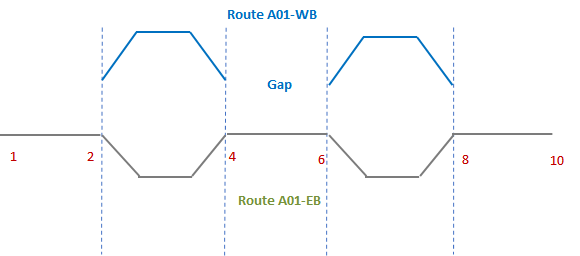
Divided highway (a.k.a. Dual carriageway) is very common in read world. It is when traffic travelling on roadways of opposite directions are separated by a central reservation. In common LRS setup, each direction is modeled as a separate route in the network. However, this often does not happen for the entirety of the route. In such case we have partially divided highway. Below is an example.

There are two data models to model partially divided highway in AgileAssets system. They are explained below.

Under this model, this is what two routes look like (distance between routes is exaggerated for displaying purpose):
The LRS database tables NETWORK_GAPS, CONCURRENT_LOCATION_DOM, CONCURRENT_LOCATION_SIB, NETWORK_LINE_DIRECTIONS and SETUP_LOC_IDENT are filled as follows, to represent the above route network.
NETWORK_LINE_DIRECTIONS | SETUP_LOC_IDENT | |||||||
LOC_IDENT | LOC_IDENT | ROUTE | LANE_DIR | FROM | TO | LANE_ID | ||
101 | 601 | A01-EB | 1 | 1 | 10 | 0 | ||
202 | 602 | A01-EB | 2 | 1 | 2 | 0 | ||
303 | 603 | A01-EB | 2 | 4 | 6 | 0 | ||
404 | 604 | A01-EB | 2 | 8 | 10 | 0 | ||
505 | 605 | A01-WB | 2 | 2 | 4 | 0 | ||
606 | 606 | A01-WB | 2 | 6 | 8 | 0 | ||
CONCURRENT_LOCATION_DOM | ||||||||
Empty | ||||||||
CONCURRENT_LOCATION_SUB | ||||||||
Empty | ||||||||
NETWORK_GAPS | SETUP_LOC_IDENT | |||||||
LOC_IDENT | ALLOW SPANNING | LOC_IDENT | ROUTE | LANE_DIR | FROM | TO | LANE_ID | |
701* | 0 | 701 | A01-WB | 0 | 1 | 2 | 0 | |
702 | 0 | 702 | A01-WB | 0 | 4 | 6 | 0 | |
703* | 0 | 703 | A01-WB | 0 | 8 | 10 | 0 | |
*NOTE: If it’s the beginning / end of the route, then these gap records are not needed. In other words, if the route starts at Milepoint 1, it is not needed to record milepoint 0 to 1 as a gap. Because that part of the route is automatically considered outside the route. Similarly, if the route ends at milepoint 8, milepoints 8 to 10 don’t need to be recorded as gap. | ||||||||
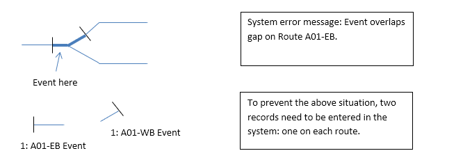
This setup will result in the following issue when recording line events when the roadways diverge or converge. 

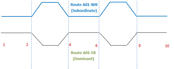
Under this model, this is what two routes look like (distance between routes is exaggerated for displaying purpose):
The LRS database tables NETWORK_GAPS, CONCURRENT_LOCATION_DOM, CONCURRENT_LOCATION_SIB, NETWORK_LINE_DIRECTIONS and SETUP_LOC_IDENT are filled as follows, to represent the above route network.
NETWORK_LINE_DIRECTIONS | SETUP_LOC_IDENT | |||||||
LOC_IDENT | LOC_ IDENT | ROUTE | LANE_DIR | FROM | TO | LANE_ID | ||
601 | 601 | A01-EB | 1 | 1 | 10 | 0 | ||
602 | 602 | A01-EB | 2 | 1 | 2 | 0 | ||
603 | 603 | A01-EB | 2 | 4 | 6 | 0 | ||
604 | 604 | A01-EB | 2 | 8 | 10 | 0 | ||
605 | 605 | A01-WB | 2 | 2 | 4 | 0 | ||
606 | 606 | A01-WB | 2 | 6 | 8 | 0 | ||
NOTE: NETWORK_LINE_DIRECTIONS table does not contain subordinate section data. | ||||||||
CONCURRENT_LOCATION_DOM | SETUP_LOC_IDENT | |||||||
DOM_LOCATION_ID | LOC_IDENT | LOC_IDENT | ROUTE | LANE_DIR | FROM | TO | LANE_ID | |
501 | 50101 | 50101 | A01-EB | 0 | 1 | 2 | 0 | |
502 | 50202 | 50202 | A01-EB | 0 | 4 | 6 | 0 | |
503 | 50303 | 50303 | A01-EB | 0 | 8 | 10 | 0 | |
CONCURRENT_LOCATION_SUB | SETUP_LOC_IDENT | |||||||
DOM_LOCATION_ID | LOC_IDENT | LOC_IDENT | ROUTE | LANE_DIR | FROM | TO | LANE_ID | |
501 | 50104 | 50104 | A01-WB | 0 | 1 | 2 | 0 | |
502 | 50105 | 50205 | A01-WB | 0 | 4 | 6 | 0 | |
503 | 50106 | 50306 | A01-WB | 0 | 8 | 10 | 0 | |
NETWORK_GAPS |
| |||||||
Empty | ||||||||
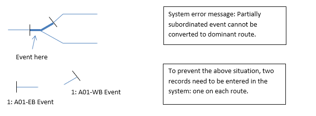
This setup will result in the following issue when recording line events when the roadways diverge or converge.
