There are four basic datasets needed for a pavement management system to function, including:
The out-of-the-box Pavement Analyst has included the basic tables and windows for these 4 datasets. As part of the configuration process, the datasets will be expanded to fit the agency’s needs, and import routines will be setup to update these datasets on a regular basis.
If customer has data other than the above-mentioned dataset defined the configuration process, additional datasets will be created and configured in a similar method to Roadway Inventory or Pavement Condition data. Follow the data import process defined by the configuration to update data.
Roadway Inventory
Roadway Inventory is for storing various roadway characteristics and their locations, such as Functional Class, Number of Lanes, Lane Width, Shoulder Width, etc. Out of the box, the table is named PMS_ROADWAY_INVENTORY, and the corresponding window is located under Pavement Analyst > Asset Inventory > Roadway Inventory > Roadway Inventory Data menu. For detailed process of navigating in this window, follow this link.
Roadway Inventory data is a strictly Location-referenced data (see detailed discussion in AgileAssets System Foundation Configuration Guide, or this link on docs.agileassets.com), i.e., the data is identified strictly by a location in the LRS network (route with "from" and "to" point boundaries).
The configuration of the system will include an import routine that allows the user to update the data on a regular basis. To execute the import routine, follow the instruction detailed in Load Data into Tables.
Pavement Condition
Pavement Condition is for storing the annual pavement condition survey results and their locations, such as IRI, Rutting, Faulting, Cracking, etc. Out of the box, the table is named PMS_AUTOMATED_CONDITION_SURVEY, and the corresponding window is located under Pavement Analyst > Asset Performance > Automated Condition Survey > Automated Condition Survey Data menu. For detailed process of navigating in this window, follow this link.
Pavement Condition data is also a strictly Location-referenced data table (see detailed discussion in AgileAssets System Foundation Configuration Guide, or this link on docs.agileassets.com), i.e., the data is identified strictly by a location in the LRS network (route with "from" and "to" point boundaries). The main difference between Pavement Condition data and Roadway Inventory data is that condition data has an EFF_YEAR field, to record data from each data year.
The configuration of the system will include an import routine that allows the user to update the data on a regular basis. The guideline for updating or creating additional import configuration is similar to roadway inventory data. One difference is that most of the time, when updating roadway inventory data, you would “replace” the entire dataset because roadway inventory is not differentiated by year, whereas for condition data, you will only import (or replace) the data with a specific year (or latest year), and leave the historical data untouched. This can be achieved by specifying a “Replace Where Clause” in the import Configuration, for example:
EFF_YEAR=2019
Traffic
Traffic is for storing the annual pavement condition survey results and their locations, such as AADT (Annual Average Daily Traffic), Truck Percentage, ESAL (Equivalent Single Axle Load), etc. Out of the box, the table is named PMS_TRAFFIC, and the corresponding window is located under Pavement Analyst > Asset Inventory > Traffic > Traffic Data menu. For detailed process of navigating in this window, follow this link.
PMS_TRAFFIC is also a strictly Location-referenced data table (see detailed discussion in AgileAssets System Foundation Configuration Guide, or this link on docs.agileassets.com), i.e., the data is identified strictly by a location in the LRS network (route with "from" and "to" point boundaries). It is very similar to the pavement condition table and also has an EFF_YEAR column to identify the data year of the record.
The configuration of the system will include an import routine that allows the user to update the data on a regular basis. The guideline for executing the import routine is similar to pavement condition data. Most of the time, when you update the traffic data, you will only import (or replace) the data with a specific year (or latest year), and leave the historical data untouched. This can be achieved by specifying a “Replace Where Clause” in the import Configuration, for example:
EFF_YEAR=2019
Pavement Structure (Construction History)
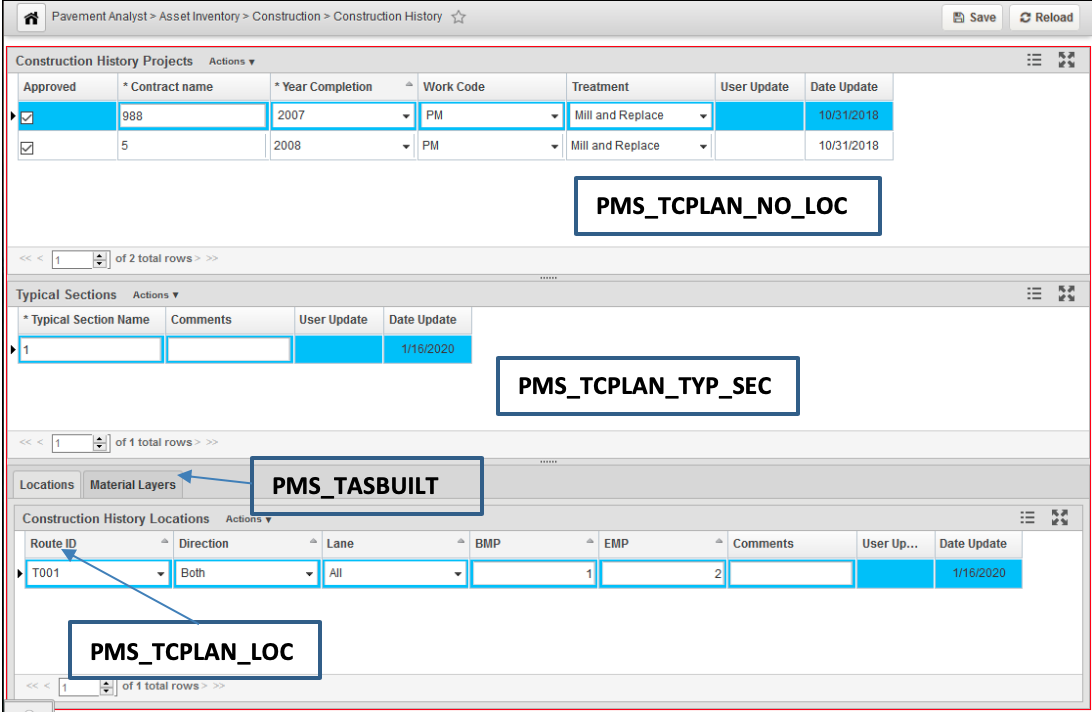
Pavement Structure (Construction History) is for storing the completed construction projects, their linear locations and material layer information of each construction location. Unlike other dataset, there are 4 system tables used for this function out of the box, and the corresponding window is located under Pavement Analyst > Asset Inventory > Construction menu.
There are 4 datasets storing the pavement structure data, corresponding to the 4 panes in the Construction History window:
- Construction History Project: This dataset stores the project-level information about each construction project and does not store any location information. The Treatment type and Completion Year information is also stored in this table. This is PMS_TCPLAN_NO_LOC table in the system.
- Typical Sections: This dataset stores Typical Sections under each project. A Typical Section is defined as the unique composition of a series of material layers within each project. In other words, within each Typical Section, the material layer compositions are expected to be the same for different locations. Each Typical Section can have multiple locations. This is PMS_TCPLAN_TYP_SEC table in the system.
- Locations: This dataset is a strictly Location-referenced dataset, i.e., the data is identified strictly by a location in the LRS network (route with "from" and "to" point boundaries) and has the location column. This table stores the linear location of each Typical Section under each construction project. This is the PMS_TCPLAN_LOC table in the system.
- Material Layers: This dataset stores the material layer information for each typical section under the project (i.e., Within each Typical Section, the material layer composition is expected to be the same). This is the PMS_TASBUILT table in the system.
The screenshot below shows in the Pavement Analyst > Asset Inventory > Construction > Construction History window.
Typically, configuration of the system will include an initial data conversion import routine that allows the user to import all the historical construction history project into the system. Once the system goes alive, user will manually add and edit the construction projects in this window. For detailed process of using this window, follow this link.
Pavement Structure Graph
Pavement Structure Graph window allows the user to specify a location (a segment of roadway), and displays all the historical construction projects on this location, both along the route and across the route. The window is located under Pavement Analyst > Asset Inventory > Construction > Pavement Structure (Profile / Cross Section) menu.
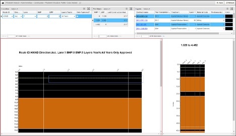
The window has 3 panes at the top:
- Location pane, where the use enters the location.
- Partition pane, where the list of Finest Partitioned project locations that fall within the location entered are displayed. In other words, each partition is homogenous with regard to construction history projects and will not cross different projects or layer compositions.
- Layers pane, where the Material Layer information from each selected construction project is displayed.
The window has 2 charts at the bottom:
- Along the Route chart, which graphically displays the layers using the defined color along the route;
- Across the Route chart, which displays the layer in the cross-section (i.e., different direction of the route) for the selected segment along the route.
Detailed usage of the window can be found here.